Zemen Monastery "St. John the Evangelist"
The Zemen Monastery is situated along the Struma River, among the beautiful landscapes of Konyavska Mountain, less than two km. away from the town of Zemen.
A mosaic of mountains, hollows and deeply cut valleys.
Kraishte – the endmost southwestern region of Bulgaria. It also spans over the eastern parts of neighbouring Serbia as well as over a small territory in Macedonia. In Bulgaria, it encompasses the area between the Serbian and the Macedonian border, the mountains of Osogovo and Rila and the Zavala-Plana Chain. It includes two mountain chains – the Ruy-Verila and the Konyavska-Milevska as well as the in-between valleys of Pernik, Breznik, Tran, Radomir, Kyustendil, Samokov, Sapareva Banya and Dolna Banya.
From the point of view of physical geography this region is an elaborate mosaic of mountains, hollows and deeply cut valleys. The Struma, Yablanishka and Erma, as well as a few smaller rivers, pass the region. Perhaps the most popular sight here is the picturesque gorge of the Erma. The natural sight is situated 3 kilometres away from the town of Tran. There is an eco-trail leading to it, equipped with wooden bridges and a tunnel under the rocks.
Other natural tourist sites include the Zemen Gorge, the Skakavitsa Waterfall and others. The only reserve in Kraishte – Ostritsa – is in Golo Bardo Mountain. The region of the town of Tran is famous for being one of the coldest places in Bulgaria – the country’s absolute minimum of -38.3 °C was measured in the Tran Valley. Kraishte doesn’t really pride itself with its greenery – its territory is severely deforested. A huge part of the terrain is grass-covered only. In some places the air, the soil and the water are highly polluted. The reasons for all this are the mining, the development of energy and metal production and other industries as well as the destruction of the plant diversity in the valleys due to their dense population.
Kraishte however is rich in mineral water. It is found in Sapareva Banya, Kyustendil, Breznik, Nevestino, Dolna Banya, Banya (Tran Region) and others.
The most ancient settlements found here date from the Late Chalcolithic Age. During the Antiquity and the Middle Ages the abundance of mineral springs attracted many settlers.
Eight thousand years of history lay upon the shoulders of Kyustendil – former city of emperors, mineral waters and fertile lands. The Byzantines built their fortress of Hisarlaka here which now rises over the town from the highest flat part of the eponymous hill. Since time immemorial its waters have attracted settlers and so the town has never ceased to exist. Today Kyustendil holds numerous traditional celebrations – a bridge between the past, the present and the future – Kyustendil Spring (“Kyustendilska Prolet”), the Cherry Festival, the Panagiya Festival and the Festival of Fertility (“Praznik na plodorodieto”).
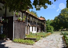
The Zemen Monastery is situated along the Struma River, among the beautiful landscapes of Konyavska Mountain, less than two km. away from the town of Zemen.
The Odranishki monastery is located in Erulska Mountain

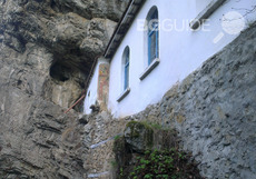
The St. Yoan Letni Chapel is located in a captivating place in the beautiful surroundings of the Pchelina Dam.
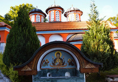
For hundreds of years the Holy Trinity Monastery has been hiding amid the wild nature of the Nishava River’s gorge with its thick forests and tall rocks.
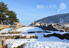
Since time immemorial a strategic fortress rises on top of a rocky plateau near present-day Pernik, on the right bank of Struma River.
Сред най-старите и запазени манастири в Софийския район, манастирът "Света Троица" днес е приятно място за отмора